Bangalore Metro Route Map: Your Comprehensive Guide to Timings, Lines, and Stations
Explore the complete Bangalore Metro route map with detailed info on lines, stations, timings, and passes. A must-read for Bengaluru commuters!
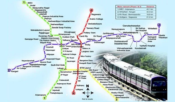
Bangalore, India’s bustling IT capital, relies heavily on its metro network for efficient transportation. The Bangalore Metro Route Map offers a seamless way to navigate the city, connecting key residential, commercial, and industrial hubs. You can explore the complete route details to plan your commute with ease. This blog covers the entire metro route, including lines, stations, and timings, providing a comprehensive guide for residents, professionals, and tourists.
Bangalore Metro: An Overview of the Namma Metro Network
Bangalore Metro, also known as Namma Metro, is the city’s rapid transit system operated by the Bangalore Metro Rail Corporation Limited (BMRCL). It offers a quick and convenient alternative to the congested roadways, helping commuters travel faster and more efficiently.
The metro system consists of multiple lines, each serving different parts of the city. With continuous expansion, it is becoming the backbone of Bangalore’s transportation network.
Bangalore Metro Route Map: Key Lines and Their Connectivity
Purple Line: East-West Corridor
The Purple Line covers the east-west corridor of Bangalore. It stretches from Challaghatta in the west to Whitefield (Kadugodi) in the east. This line passes through significant areas, including:
-
Mysore Road – A vital junction connecting to the outer areas.
-
K.R. Market – A key commercial hub.
-
MG Road – Bangalore’s shopping and business district.
-
Whitefield – A major IT and residential area.
Green Line: North-South Corridor
The Green Line forms the north-south corridor, connecting Nagasandra to Silk Institute. This line crosses central parts of the city, including:
-
Yeshwanthpur – A major industrial and residential area.
-
Rajajinagar – Known for its commercial and residential significance.
-
National College – Located near Basavanagudi.
-
JP Nagar – A popular residential locality.
Yellow Line: Connecting RV Road to Bommasandra
The Yellow Line links RV Road in the city center to Bommasandra, a prominent industrial area in the south. This line boosts connectivity between residential and employment zones, reducing commute times.
Blue Line: Connecting Outer Areas
The upcoming Blue Line is part of the metro expansion plan. It will link Central Silk Board to Kempegowda International Airport, offering direct access for airport commuters.
Pink Line: Enhancing Connectivity in the North
The Pink Line, under construction, will connect Kalena Agrahara in the south to Nagawara in the north. This line aims to reduce congestion by providing an alternate route to the central metro lines.
Metro Stations: Major Hubs and Interchange Points
Key Interchange Stations
Interchange stations play a crucial role in streamlining travel across different metro lines. Some of the major interchange stations include:
-
Majestic (Nadaprabhu Kempegowda) – Links the Purple Line and Green Line, making it the busiest interchange.
-
KR Puram – A vital link for commuters on the Purple Line and future expansion projects.
-
Jayadeva Hospital – Connects the Yellow Line and Pink Line (once operational).
Prominent Metro Stations and Their Locations
-
Baiyappanahalli – Serves commuters heading towards Whitefield and surrounding areas.
-
Peenya – An industrial area with significant daily footfall.
-
Vijayanagar – A popular residential neighborhood.
-
Mysore Road – A key terminal on the Purple Line.
Metro Timings: Schedule and Frequency
Weekday Metro Timings
The Bangalore Metro operates at regular intervals, making it a reliable mode of transport for daily commuters. During peak hours, the frequency is higher, ensuring shorter waiting times.
Weekend and Holiday Timings
On weekends and public holidays, the metro runs at slightly reduced frequencies. However, extended hours during festive seasons and special events accommodate higher passenger volumes.
First and Last Train Timings
-
First Train: Metro services usually commence in the early morning.
-
Last Train: The last trains operate until late night, making it convenient for late-night commuters.
Benefits of Using Bangalore Metro for Daily Commute
Reduced Travel Time
Bangalore’s traffic congestion is notorious. The metro offers a faster and more predictable travel option, significantly reducing commute times.
Comfortable and Safe Journey
With air-conditioned coaches and well-maintained stations, the metro ensures a comfortable and safe commute. CCTV surveillance and security personnel enhance passenger safety.
Affordable and Eco-Friendly Travel
The metro offers an economical way to travel long distances. It also promotes eco-friendliness by reducing vehicular emissions and traffic congestion.
Expansion Plans: Upcoming Metro Projects in Bangalore
Airport Metro Line
The Blue Line project, connecting Silk Board to Kempegowda International Airport, will significantly enhance connectivity for travelers. This line will include stations at:
-
Electronics City – A major IT and business hub.
-
Hebbal – A prominent residential and commercial area.
-
Airport Terminal – Providing direct access to the airport.
Pink Line Completion
Once fully operational, the Pink Line will decongest central areas, offering a smoother travel experience for commuters from South Bangalore to North Bangalore.
Peripheral Ring Metro Project
The BMRCL plans to introduce a Peripheral Ring Metro to cover the city’s outskirts. This project aims to ease connectivity between suburban areas and the central metro network.
Tips for Metro Commuters
Use Smart Cards
Opt for a metro smart card for seamless and cashless travel. It offers convenience and faster entry and exit at stations.
Plan Your Route in Advance
Check the Bangalore Metro Route Map and timings before starting your journey. Use metro apps or official websites for real-time updates.
Avoid Rush Hours
Traveling during non-peak hours ensures a more comfortable commute. Morning and evening rush hours witness higher footfall.
Conclusion
The Bangalore Metro Route Map offers a fast, reliable, and eco-friendly transportation solution for the city’s growing population. As the network expands, it continues to enhance connectivity and reduce travel times. For any inquiries or route-related information, contact us.
Frequently Asked Questions
1. What is the total length of the Bangalore Metro network?
The Bangalore Metro network currently spans over 70 kilometers across multiple operational lines. With the ongoing expansion projects, the network will cover a larger area, enhancing city-wide connectivity.
2. How many metro lines are currently operational in Bangalore?
As of now, the Purple Line and Green Line are fully operational. The Yellow Line and Pink Line are under construction, while the Blue Line (airport line) is part of future expansion plans.
3. Where can I find the latest Bangalore Metro Route Map?
You can view and download the latest Bangalore Metro Route Map from the official BMRCL website or trusted platforms that offer real-time metro updates.
4. Which metro line connects to Bangalore International Airport?
The Blue Line, currently under construction, will connect Silk Board to Kempegowda International Airport, providing a direct and faster transit option for air travelers.
5. What are the major interchange stations on the Bangalore Metro?
Key interchange stations include:
-
Majestic (Nadaprabhu Kempegowda) – Connecting the Purple and Green lines.
-
Jayadeva Hospital – Future interchange for the Yellow and Pink lines.
-
KR Puram – Planned interchange for future expansion routes.
6. What are the Bangalore Metro's operating hours?
The metro services typically operate from early morning until late night, with increased frequency during peak hours. Timings may vary slightly on weekends and public holidays.
7. Is there a metro service available to Electronic City?
Yes, the Yellow Line (under construction) will connect RV Road to Bommasandra, covering Electronic City, a major IT hub.
8. How frequent are Bangalore Metro trains during peak hours?
During peak hours, metro trains operate at a frequency of 4-5 minutes, while during non-peak hours, the interval increases to 10-15 minutes.
9. Are there smart cards available for metro travel?
Yes, the Bangalore Metro Smart Card offers cashless travel and faster entry and exit at stations. It is highly recommended for regular commuters.
10. Can I carry luggage on the Bangalore Metro?
Yes, passengers are allowed to carry small and medium-sized luggage. However, large or bulky items may not be permitted due to space constraints.
What's Your Reaction?


.jpg)
